
 |
| (Remnants of Ophelia) |
 |
| (Remnants of Ophelia) |
 |
| (Remnants of Ophelia) |
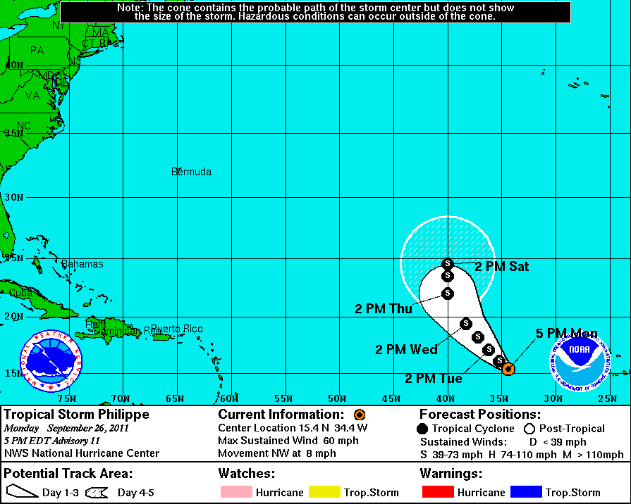
Tropical Storm Philippe wasn't able to gain any strength through out the day today. Dry air and a little wind shear from the north kept him at bay. A little bit of his surface flow was exposed on the north side. But Philippe was able to keep some strong convection going to at least maintain his standing as a 60 mph tropical storm with a pressure holding at 997 mb.

The forecast for Philippe has not changed much, besides the Hurricane Center reducing his probability of becoming a hurricane. They now say that he has a 21% chance of reaching hurricane strength by Tuesday at 2PM. That is his timetable. Philippe has about another 24 hours in a favorable environment, so if he is going to become the seasons 4th hurricane, he needs to do his thing now. NHC is forecasting that he will strengthen a bit more and top out at 65 mph sustained. So it will be close. We'll see what Philippe has got.
This area in the south central Caribbean is only worth a quick mention for right now. It has recently become more active than it's been for months. That is not only the area to watch normally as October approaches, but it is an area that long range global models are hinting at for development sometime next week as upward motion returns to the Caribbean for the season finale. Even though the Caribbean and Gulf of Mexico is forecast to remain a hostile environment, we could see a weak hurricane in there pretty soon. Probably not before September ends though, so we will likely close out the month with Philippe. In the record breaking '05 season, we closed out September on Hurricane Rita, just one letter ahead of where we are now. Stan through Zeta occurred after October 1st.
 |
| (Active Area in the south central Caribbean) |
No comments:
Post a Comment