 |
| (Invest 99L) |

Nov 22, 2011
DAY 174
With just 9 days left in the 2011 Hurricane Season, Tammy is looming in the North Atlantic. A low pressure system has developed a very healthy surface circulation and has been designated Invest 99L. The National Hurricane Center in giving it a 60% chance of becoming a named sub-tropical system within the next 48 hours. The convection is being push off of the center by some strong southwesterly wind sheer at the moment. It is also about to move north of 30N, which means the water temperatures will no longer be favorable for development. Despite these adversaries, there is strong support from the computer models for 99L to at least develop in to Sub-Tropical Storm Tammy. The chance of this system actually transitioning into a tropical classification has got to be very low given the water temperatures out there. Invest 99L's best chance of development will probably be tomorrow. If it misses that chance, I figure that conditions will become far less favorable as it moves to the northeast.
Nov 11, 2011
DAY 163
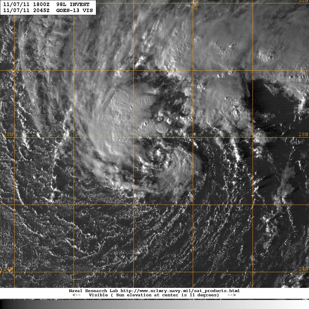
Tropical Storm Sean has now merged with that trough and has gone post tropical. The satellite picture below was the last discernible image of Sean. You can see the boundary were the cold front and the western edge of Sean met, and the surface swirl with its convection sheared to the east. Sean picked up his pace to above 30 mph and is racing off to the northeast towards Newfoundland. With just 19 days left in the 2011 Hurricane Season, we have 3 names left, and are 1 storm away from matching last years number at T. The GFS shows some hint of organization but no solid leads for the coming week. This might be it people.
 |
| (Tropical Storm Sean) |
DAY 162
Tropical Storm Sean was unable to reach hurricane strength today and he is now out of time. He is moving into the cold waters of the north Atlantic and he has also received a pretty good first punch from the front of a trough sweeping off of the US east coast. You can see the flat line move across the visible satellite loop below from east to west. The upper portion of the storm is being pushed away first. This trough will eventually consume Tropical Storm Sean and pull his remnants north towards the other low. Sean's center still remains in tact for the most part tonight. He is even still maintaining sustained winds of 65 mph. The NHC is forecasting Sean to last another 8 hours as he brings tropical storm conditions to Bermuda. He may be able to survive until tomorrow afternoon, but we will soon close the book on the 18th tropical cyclone of the season.
 |
| (Tropical Storm Sean) |
Nov 9, 2011
DAY 161
Tropical Storm Sean has made his move to the north and has picked up his pace to a whopping 8 mph. Sean was also able to strengthen to a 65 mph sustained storm today. The tightening that was seen from the visible satellite during the day, started to open back up after the sun set. This doesn't look like a storm that is about to become a hurricane, but he certainly will have a shot. The Hurricane Center is giving Sean about a 50/50 chance right now, but they are leaning towards Sean becoming a hurricane tomorrow night. If he is able to pull this off, Sean would become our 7th hurricane of the season.
 |
| (Tropical Storm Sean) |
DAY 161
Sean has apparently had no problem transitioning from a sub-tropical structure to a tropical storm. He is now relying on warm moist air from sea surface evaporation to fuel his circulation. The NHC is forecasting Sean to remain a tropical storm for 2 more days, as he gets swept up to the north. Once he gets above 30N, the ocean surface temperature will no longer be able to support the growth of a tropical cyclone, and Sean will begin to die. He will have a very difficult time gaining much more strength before then, although the NHC is giving Sean good odds of topping out at a 65 mph tropical storm on Thursday. He is going against the grain right now, once he turns to the north, upper level winds will become more favorable, and he will also be moving away from the bulk of dry air. Sean may bring Bermuda some moderate effects on Thursday night.
The Mediterannean Storm that the US Navy has identified as Invest 99L is about to make landfall in the French Riviera. It will likely bring tropical storm force sustained winds and heavy rainfall to that area.
 |
| (Tropical Storm Sean) |
 |
| (Time Lapse of Invest 99L) |
Nov 8, 2011
DAY 160
Invest 98L is on the verge of becoming Sub-Tropical Storm Sean. It is located about 460 miles southwest of Bermuda, and has been drifting slightly westward throughout the day. The National Hurricane Center is giving it a high probability of developing into a sub-tropical cyclone in the next 48 hours at 80%. Invest 98L is in a battle with dry air which pretty much surrounds it. There is also some southwesterly shear. This storm is expected to move very slowly to the west if not remain stationary for a couple of days before being swept of to the north by a trough. This storm will likely never impact any landmass nor become fully tropical.
Also in the Sub-Tropics, there is a rare storm brewing in the Mediterranean Sea. Even though this is an Atlantic Invest, this will not receive an Atlantic name if it develops, nor is the NHC responsible for issuing warnings on it. Storms so rarely develop in the Mediterranean that none of the worlds meteorological organizations claim the area.
 |
| (Invest 98L) |
Also in the Sub-Tropics, there is a rare storm brewing in the Mediterranean Sea. Even though this is an Atlantic Invest, this will not receive an Atlantic name if it develops, nor is the NHC responsible for issuing warnings on it. Storms so rarely develop in the Mediterranean that none of the worlds meteorological organizations claim the area.
 |
| (Invest 99L) |
Oct 29, 2011
DAY 150
Rina died almost as fast as she was born, as the trough diving down into the Gulf has severed her in half. The mid-level portion of Rina was drawn up to the northeast and is making a rainy impact on south Florida. While her remnant surface low moved off to the ESE and is about to collide with a tropical wave. The NHC is giving that wave a 10% chance of developing into a tropical cyclone in the next 48 hours. The GFS is keeping low pressure in the Caribbean all next week, and is hinting at more development. The area remains active but also hostile.

Oct 27, 2011
DAY 149
Rina is making landfall right now in the Yucatan as a 60 mph tropical storm. Southerly shear has finally done some damage on Rina, removing her convection to the north of her center. This is good news for Mexico, as they will get far less rain than what was forecast, and less of a storm surge as well.
Moisture from the tropical wave formerly known as Invest 97L has arrived to late for Rina. It may help her maintain tropical storm strength for a while. But there is a cold front digging in through the southern states and will soon deliver another punch to Rina. The Hurricane Center is still forecasting Rina to be pushed back to the south as a depression, and the computer models do support that solution.

If Rina doesn't try to do battle with that trough and moves south or stalls, she may be able to stay alive for several days. Maybe even make a second landfall on the Yucatan. A move to the northeast is unlikely now, and would spell disaster for Rina. It's hard to tell if her latest burst of convection is because she's getting a charge of moisture from the southeast, or if she's just taking advantage of the Diurnal Maximum. If it's the latter, than she may go into dissipation mode tomorrow morning. Most likely though, the NHC forecast is correct. The center of circulation appears to be catching back up with the convection and will be able to survive another day as a tropical storm just off the coast of Cancun.

 |
| (Tropical Storm Rina) |
If Rina doesn't try to do battle with that trough and moves south or stalls, she may be able to stay alive for several days. Maybe even make a second landfall on the Yucatan. A move to the northeast is unlikely now, and would spell disaster for Rina. It's hard to tell if her latest burst of convection is because she's getting a charge of moisture from the southeast, or if she's just taking advantage of the Diurnal Maximum. If it's the latter, than she may go into dissipation mode tomorrow morning. Most likely though, the NHC forecast is correct. The center of circulation appears to be catching back up with the convection and will be able to survive another day as a tropical storm just off the coast of Cancun.
DAY 148
Hurricane Rina has been reduced to a category 1 hurricane today, and never did reach major hurricane status last night. There is no real smoking gun on the evidence list that caused this rapid deterioration. It is most likely a combination of small changes to several variables that added up to one big blow. The most noticeable wound is to her feeder system. The banding features are nearly gone, indicating that she has been having troubles pulling in the moister around her.
Wind shear has remained at moderate levels according to CIMSS shear analysis, and Rina certainly doesn't have the appearance of a sheared system. But it is possible that wind shear is partially responsible for the erosion of the feeder bands. Upper level wind shear looks to have disrupted her exhaust system as well. Without a proper outflow, surface pressures will stop falling. There is no evidence of dry air being injected into Rina's core, and the dry air to the north has actually receded a bit. But that dry air could have played a role in the erosion of the outer edges of Rina.
It is also possible that turbulent land/sea breeze interaction is also tampering with Rina now that she has moved so close to land. One thing that is still in Rina's favor is that her inner core seems to still be in tact. As long as she has that, she can still experience brief periods of strengthening. Her strongest days are probably behind her now though, it would be a huge surprise if she is able to build back up to 110 mph sustained winds. The environmental conditions are expected to remain the same for tomorrow as she approaches Cozumel, so she may fluctuate between 75 and 95 mph sustained until landfall. Although it is starting to look like she might make landfall just a bit further south of her forecast, which means more time over land. That could very well mean the end for this small, struggling storm. That is good news for residents in the Yucatan, as just last night they were bracing themselves for the possibility of a major hurricane landfall.
The only other variable would be ocean temperature. We know that slow moving hurricanes can cool sea surface temperatures below. But that is rarely an issue in the Caribbean, where the waters are warmer at depth. But our satellites can't get a good measurement with cloud cover blocking their signal, and there is not a buoy located under Rina at her current position. So we really don't know how ocean temps are affecting her right now.

The Hurricane Center is now forecasting a weaker hurricane to still hit Cozumel tomorrow night. Then the NHC forecast track turns Rina to the east and hooks her to the south near the western edge of Cuba. The 18z model runs actually showed a consensus among the GFS, HWRF and even the GFDL which has finally moved in line with the others showing that hook to the south.
 |
| (Hurricane Rina) |
 |
| (Hurricane Rina Water Vapor Loop) |
 |
| (Hurricane Rina Microwave Image) |
The Hurricane Center is now forecasting a weaker hurricane to still hit Cozumel tomorrow night. Then the NHC forecast track turns Rina to the east and hooks her to the south near the western edge of Cuba. The 18z model runs actually showed a consensus among the GFS, HWRF and even the GFDL which has finally moved in line with the others showing that hook to the south.
Oct 26, 2011
DAY 147
Hurricane Rina was able to slowly strengthen throughout the day, and is now poised to become a major hurricane. It will likely be able to do that within the next 3 to 6 hours. The NHC is forecasting Rina to top out as a weak Cat 3 with maximum sustained winds of 115 mph. She will likely only be able to sustain herself for 1 more day before conditions deteriorate and begin to break her down. Rina's eye has been wobbling all day and has not been able to tighten a perfect spin yet.
Rina is a very small hurricane. She has built up a wall of storms mostly surrounding her eye now, and has been able to fend off most of the dry air that is leaning up against her north and west flank. That dry air has managed to disrupt her feed from that side though. Her strongest feed is from the south, probably aided by Pacific moisture. She is also benefiting from some of the warmest waters in the Caribbean in that location. Even though she has not moved much over the last day or so, upwelling shouldn't be much of an issue in that location due to the greater depth of warm water there.
It now looks fairly certain that Rina will strike the edge of the Yucatan as a Cat 3 or strong Cat 2 hurricane on Thursday. The NHC's Tropical Analysis and Forecast Branch is calling for 8-16 inches of rain and a dangerous storm surge. This will effect the 700,000 plus residents of the Cancun/Cozumel area. Rina is still headed west slowly but looks like she is ready to make a course adjustment to the northwest.


The GFDL is still sticking with a solution that brings Rina to south Florida as a Cat 1 hurricane. If Rina is somehow able to maintain hurricane strength as she moves into the Gulf, this scenario could play out. Maybe not as far north up the Florida Peninsula as the model shows, but maybe a Key West Scenario.

This is the Hurricane Wilma scenario. The water vapor image below is of Wilma making landfall on Cozumel as a Cat 4 in 2005. She then moved across the Yucatan mainland and turned to the northeast towards Florida. Note the same swath of dry air that exists today for Rina. The big difference is the size and intensity of the hurricane. Wilma was not going to be pushed around by a pesky front. The set up is similar though, and climate history should still play a role in creating a forecast. I'm not saying that Rina is going to explode, but I will never forget how surprised I was when I woke up on the morning of October 19th, 2005, and saw that Wilma went from Cat 1 to Cat 5. Wow.
 |
| (Hurricane Rina) |
 |
| (Hurricane Rina Microwave) |
What happens after she impacts the Yucatan is not yet clear. The NHC has now rounded out their forecast track a bit and guides Rina into the Florida Straights on Sunday. The 18z HWRF model has now joined the GFS in the solution that the incoming trough turns Rina back to the south. While the Navy and and the Canadian model still dissipate Rina over the Yucatan.
The GFDL is still sticking with a solution that brings Rina to south Florida as a Cat 1 hurricane. If Rina is somehow able to maintain hurricane strength as she moves into the Gulf, this scenario could play out. Maybe not as far north up the Florida Peninsula as the model shows, but maybe a Key West Scenario.
This is the Hurricane Wilma scenario. The water vapor image below is of Wilma making landfall on Cozumel as a Cat 4 in 2005. She then moved across the Yucatan mainland and turned to the northeast towards Florida. Note the same swath of dry air that exists today for Rina. The big difference is the size and intensity of the hurricane. Wilma was not going to be pushed around by a pesky front. The set up is similar though, and climate history should still play a role in creating a forecast. I'm not saying that Rina is going to explode, but I will never forget how surprised I was when I woke up on the morning of October 19th, 2005, and saw that Wilma went from Cat 1 to Cat 5. Wow.
 |
| (Hurricane Wilma Water Vapor, 2005) |
Oct 24, 2011
DAY 146
From a depression to a hurricane in just 21 hours, Rina is now a category 1 hurricane. Impressive plumes of convection can be seen in and around the center of circulation. There is nice banding around the bottom and sides of Rina, but the northern section is still being pulled to the northeast by an escaping trough. That is the same trough that was guiding Rina to the north yesterday, but as it moves away, Rina has taken a more westward turn.
Hurricane Rina is forecast to continue strengthening. The microwave image is very revealing in that. Strong storms have built up half way around the center of circulation. That tight circulation indicates strengthening winds that are probably well in excess of 75 mph. That center will probably be able to close off over night and we should wake up to a visible eye in Rina's center tomorrow.
The National Hurricane Center was just as surprised as everyone else with Rina's rapid growth. They are now forecasting Rina to become a major hurricane by tomorrow night, and that's probably a safe bet given her behavior to this point. The NHC is also forecasting Rina to continue moving slowly WNW for the next 48 hours and then turn to the north just as she approaches the Yucatan. That is the result of an approaching trough from the U.S., but then they are calling for a peculiar and abrupt turn to the east. The only computer model that supports that move is the GFS which turns Rina back to the south again.

There is still some decent among the models with the Navy model still forecasting a westward move over the Yucatan Peninsula, while the Canadian meanders Rina around and then dissipates her before she even reaches the landmass. These are unlikely scenarios, the first due to high pressure over the Yucatan, and the other due to the strength that Rina has already attained. The GFDL and the HWRF take Rina to the northeast in a more rounded fashion between Cancun and Cuba.

It is likely that Rina will be a strong hurricane on Thursday as she moves into the Yucatan landmass. There is a large swath of dry air to her north and west. There has not been much evidence of that air getting into Rina's core, but I assume that that will eventually happen. There is a surge of moisture from a tropical wave approaching quickly from the southeast. That could help supply Rina with additional water vapor. Otherwise that dry air, along with the timing of a cold front will eventually weaken Rina as she approaches the Florida Straights.
Invest 97L is still out there. That is the moisture that is moving in on Hurricane Rina from the southeast. There still is no real organization to this system, but it does have some computer model support for future development. This Invest could be the wild card the tracking of Hurricane Rina. If 97L closes off a surface low as it moves in on a slow moving Hurricane Rina, it could cause a Fujiwara tug, pulling Rina to towards the other low. NHC is giving Invest 97L a 20% chance of becoming a tropical cyclone in the next 48 hours.
 |
| (Hurricane Rina) |
 |
| (Hurricane Rina on Microwave Satellite Image) |
There is still some decent among the models with the Navy model still forecasting a westward move over the Yucatan Peninsula, while the Canadian meanders Rina around and then dissipates her before she even reaches the landmass. These are unlikely scenarios, the first due to high pressure over the Yucatan, and the other due to the strength that Rina has already attained. The GFDL and the HWRF take Rina to the northeast in a more rounded fashion between Cancun and Cuba.
It is likely that Rina will be a strong hurricane on Thursday as she moves into the Yucatan landmass. There is a large swath of dry air to her north and west. There has not been much evidence of that air getting into Rina's core, but I assume that that will eventually happen. There is a surge of moisture from a tropical wave approaching quickly from the southeast. That could help supply Rina with additional water vapor. Otherwise that dry air, along with the timing of a cold front will eventually weaken Rina as she approaches the Florida Straights.
 |
| (Hurricane Rina Water Vapor Loop) |
 |
| (Invest 97L) |
Oct 23, 2011
DAY 145
Tropical Depression #18 has formed out of Invest 96L and it is on the verge of becoming Tropical Storm Rina. That should happen within the next 6 hours. The plume of convection is gradually beginning to align itself over the surface circulation. Conditions will remain moderately favorable for development until it either reaches the Yucatan Peninsula or the dry air in the Gulf of Mexico.
The National Hurricane Center is forecasting TD#18 to become Rina and then remain a tropical storm for the next 5 days before making landfall in the Yucatan. The forecast models seem to agree with this assessment. Most of the models are forecasting TD#18 to dissipate over the Yucatan as TS Rina, except the HWRF, which keeps it in tact as a trough sweeps it off to the northeast. Guidance is to the west right now but TD#18 is continuing to move to the NNW and appears to be wandering off course just a bit. If the track adjusts a bit further north, that would increase the chances of TD#18 surviving an impact with the landmass.

Invest 97L is still alive tonight, but doesn't look much better today. The NHC is giving it a 10% chance of becoming a tropical cyclone in the next 48 hours. A couple of the computer models are showing some development of this Invest after it crosses the Antilles Islands.
 |
| (Tropical Depression #18) |

Invest 97L is still alive tonight, but doesn't look much better today. The NHC is giving it a 10% chance of becoming a tropical cyclone in the next 48 hours. A couple of the computer models are showing some development of this Invest after it crosses the Antilles Islands.
 |
| (Invest 97L) |
DAY 144
Invest 96L is a threat for tropical development. It looks like it will scrape the Mosquito Coast of Central America over the next 2 days, which will stall some of its development. But conditions down there are prime for growth after it moves away from the land mass. 96L's best chance for development will be in a couple days when it is between Honduras and Belize. The Hurricane Center is giving it a 50% chance to develop in the next 48 hours.
Computer models are split on 96L's future. 2 models develop it into a named system, while the global models are now dissolving 96L. It doesn't look like much right now, and dry air in the Gulf could spell future problems for this system.
Invest 97L is an even less impressive system. The NHC is giving it a 10% chance of developing over the next 48 hours. There is some model support for Invest 97L developing some as it continues to move through the lower Antilles Islands. This development will be very slow to occur if it does.
 |
| (Invest 96L) |
 |
| (Invest 96L) |
 |
| (Invest 97L) |
Oct 16, 2011
DAY 137
The disturbance in the Caribbean has now been designated Invest 95L, and is slowly trying to get its act together. It looks like the main low has moved over the Yucatan Peninsula and will not be able to further develop. It will either have to remain intact until it moves over the water again, or a new low will have to become the dominate circulation. Despite Invest 95L's lackadaisical posture, it is in a race to organize before getting yanked out of the Caribbean by the next trough. It is forecast to meander about the Yucatan for a few days and then be pulled up to the northeast. The forecast models are still not enthusiastic about developing Invest 95L into a tropical storm. But it does spell thunderstorm activity for the Yucatan area, central Caribbean islands and Florida for the next few days. South Florida will have the potential for some rotating thunderstorms and heavy downpours.
The other feature out there is about 900 miles WSW of the Cape Verde Islands. It has not been designated an official invest, but a GOES floater has been assigned to watch the area, and it is even labeled "Invest" on NHC's satellite imagery page. It doesn't have a true identity to it anyway. It's just a poorly organized tropical wave that is drawing some energy from the ITCZ. Computer models are showing this wave to weakly wander westward with no major development. The NHC is only giving it a 10% chance of developing in the next 48 hours.

 |
| (Invest 95L) |
Oct 15, 2011
DAY 136
The area of interest near the Yucatan Peninsula has not organized any today, but it is still churning up that spot. The National Hurricane Center has not named it an official tropical invest yet, but that is just a matter of time. They are giving this disturbance a 20% chance of becoming a tropical cyclone in the next 48 hours. It is a very broad low pressure region that has a lot of consolidating to do. There is no obvious center right now, the best guess would be somewhere in the vicinity of Belize. Land interaction will be a problem for this system. Not only for the actual low over land, but if it is in the waters just off the coast, a sea breeze circulation can battle it by raising surface pressure. This disturbance looks like it will have a rough go of it for a while, especially if it moves directly over the Yucatan.

Another area that is being mentioned tonight is also along the convergence zone. But this one is near the main part of the ITCZ near Africa. It is likely a wave that is interacting with the convergence zone. This system could be Invest 95L tomorrow, the NHC is giving it a 10% chance of becoming a tropical cyclone in the next 48 hours. The environment is only marginally favorable for development due to some moderate upper level wind shear. Computer models are showing some development of both of these features, but not as far as developing into a tropical storm.

Another area that is being mentioned tonight is also along the convergence zone. But this one is near the main part of the ITCZ near Africa. It is likely a wave that is interacting with the convergence zone. This system could be Invest 95L tomorrow, the NHC is giving it a 10% chance of becoming a tropical cyclone in the next 48 hours. The environment is only marginally favorable for development due to some moderate upper level wind shear. Computer models are showing some development of both of these features, but not as far as developing into a tropical storm.

Oct 14, 2011
DAY 135
The National Hurricane Center has highlighted 2 areas of interest tonight. One system located to the northeast of the Bahamas has be designated Invest 94L. It is a fairly empty swirl that is moving harmlessly out to sea. The NHC is only giving it a 10% chance of developing into a tropical cyclone in the next 48 hours due to wind shear and it's likelihood of being absorbed by a frontal system.
The other feature is located in the vicinity of the Yucatan Peninsula. It is a very broad low pressure system that is expected to slowly wind up and organize over the next few days. There is very little organization to it yet and the NHC is giving it a 20% chance of developing into a tropical cyclone over the next 48 hours.

 |
| (Invest 94L) |
Oct 13, 2011
Oct 12, 2011
Oct 10, 2011
DAY 132
Invest 93L or "Near Tropical Storm No-Name", as the natives have been calling it today, is just about to be deactivated. Despite it's visual presentation being more impressive today, and it's central pressure lowered to 1002 mb, Invest 93L has been removed from the NHC's Tropical Weather Outlook tonight. With the weak center of circulation over land, it may actually dissolve before it gets swept up northeast, so this Invest will no longer be a threat to develop.
There can actually be a case made for this storm having been named Rina last night. It was without question producing tropical storm force winds on the Florida coast, with gusts close to hurricane strength. For a brief time, it appeared to have closed off a center just before moving ashore near Cape Canaveral. I don't believe that the whole warm core/cold core issue applies to the storm naming convention any longer. Invest 93L was a least partially warm core, so the NHC could have named it Sub-Tropical Storm Rina.
In years past, we of the weather blogging community, would have hammered the Hurricane Center for actually wasting a name on such a piddly system. So I must applaud the NHC for exercising some restraint on this one. There are still some judgement calls that must be made after the data leads up to the borderline. This one could have gone either way, and I must say they made the right call here.
 |
| (Invest 93L) |
 |
| (Invest 93L Microwave Image) |
Oct 9, 2011
DAY 131
The disturbance that has been pestering the Florida peninsula since Friday, has now been designated Invest 93L by the National Hurricane Center. An organizing surface low is located off the east coast near Melbourne. The visible image from outer-space is showing that cyclonic turning in the clouds.
There are actually 2 surface lows that have formed in this large disturbed area. The one on the east coast, and there's another in the Gulf of Mexico. This may be the reason the computer models were initially split on the initiation of this system. It also shows how unorganized this disturbance really is.

The low on the east coast is the dominant low. The vorticity for that low is actually quite strong. It is bringing tropical storm conditions to the east coast of Florida. Sustained winds in Brevard and Volusia county have been in the mid 40's with gusts higher than 50 mph. If this Invest could close off a surface circulation, it would be upgraded to a tropical depression. But it is about move over the landmass near northern Brevard County, so it is unlikely to develop further. The NHC is only giving Invest 93L a 30% chance of developing into a tropical or sub-tropical cyclone in the next 48 hours.

Invest 93L has been a heavy rainmaker as well. Especially in Central Florida. The image below is storm total rainfall estimated by Doppler radar. There are a few spots along the Osceola/Brevard county line that have received 10 plus inches thus far. 6 plus inches is prevalent across the board.

 |
| (Invest 93L) |
The low on the east coast is the dominant low. The vorticity for that low is actually quite strong. It is bringing tropical storm conditions to the east coast of Florida. Sustained winds in Brevard and Volusia county have been in the mid 40's with gusts higher than 50 mph. If this Invest could close off a surface circulation, it would be upgraded to a tropical depression. But it is about move over the landmass near northern Brevard County, so it is unlikely to develop further. The NHC is only giving Invest 93L a 30% chance of developing into a tropical or sub-tropical cyclone in the next 48 hours.
Invest 93L has been a heavy rainmaker as well. Especially in Central Florida. The image below is storm total rainfall estimated by Doppler radar. There are a few spots along the Osceola/Brevard county line that have received 10 plus inches thus far. 6 plus inches is prevalent across the board.

DAY 130
With Tropical Storm Philippe passing on as a post-tropical cyclone, we can now draw our attention to the Caribbean for the next 3 or 4 weeks. There is a developing situation near the Florida peninsula right now. Wind and rain persisted throughout the day today, as a cyclone tries to develop in the area. I snapped off a little video on my I-Phone as we were visiting family in New Smyrna Beach.
There are 3 features affecting the weather here. There is a surface trough left over from an old front that extends from Hispaniola all the way through the Bahamas. This is the feature that we will be watching for development of a closed surface low. That boundary is providing surface convergence all over that area.

There is also an upper level low spinning in the Gulf near Florida's west coast. This feature is providing divergence aloft, which is helping to lift storms and lower surface pressure in the area. The main flow pattern in the area is east to west from the bottom of a high pressure system in the northeast US. All these ingredients are coming together to try to close off a surface low.

The National Hurricane Center has not deemed this spot an area of Invest yet, but they did mention it in their Tropical Weather Outlook tonight. They are giving this system a 30% chance of developing into a tropical or sub-tropical cyclone in the next 48 hours. A closed low could develop anywhere around this very broad disturbance, but the only interesting spot right now is near the Keys. Radar in south Florida shows storm motion to the north between the Keys and the Bahamas. And storm motion to the west over the southern tip of Florida. And even a little motion to the south out west of Naples. Computer models do support this location as a point of origin. The CMC and the GFS both initiate a low near this area that moves to the northwest into the Gulf of Mexico. Neither of those models go as far to develop this into named storm, although that is still possible. We've seen disturbances go from nothing to something very quickly in this area before. Claudette in 2009 comes to mind right off the bat. Either way, Florida is looking at a couple more days of wind and rain.

Oct 8, 2011
DAY 129
Philippe is now back down to tropical storm strength and is starting to move off to the northeast. 50 to 60 knot wind shear started to do it's work this afternoon, pushing the convection of Hurricane Philippe away from the center of circulation. He will continue to weaken while moving over cold ocean water, reaching Iceland by the middle of next week.
 |
| (Tropical Storm Philippe) |
Subscribe to:
Posts (Atom)