Sep 30, 2011

DAY 122

Hurricane Ophelia has defied her forecast and decided to become a major hurricane. At 956 mb with maximum sustained winds of 120 mph, she is our 3rd major hurricane of the season. And she's not showing any signs of slowing down yet either. 

(Hurricane Ophelia)
Ophelia is a very nice looking cane. Her eye is not clear, but it is maintaining a perfect circle now. The main ring of thunderstorms that create her eye-wall are thick and tall all the way around. A little further out on her west side, you can see that some of the the thunderstorms out there are encountering some dry air and collapsing before they can be of full benefit to Ophelia's strength. But none of that dry air has been able to penetrate the eye-wall today.

(Hurricane Ophelia)

The National Hurricane Center has not changed their track except for the 5th day. They have now moved her away from Newfoundland. They did adjust their intensity forecast to keep Ophelia as a major hurricane for another day. They are only giving her a 5% chance of becoming a Cat 4 over the next 24 hours. But we all know that Ophelia is a storm that does whatever she wants, and she's
 only 11 mph from Cat 4 status. I don't think she will defy her track forecast though, and make a surprise visit to Bermuda. As Ophelia passes to the east of the island, they will get brushed by that western edge of Ophelia. Which is the side that is being effected by dry air. The NHC is giving a Bermuda a less than 50% chance of receiving tropical storm force winds and a near 0% chance of hurricane force winds.


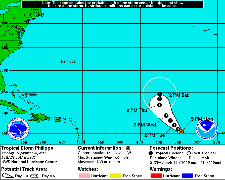
Tropical Storm Philippe is holding his own out there. He looks much better than he did yesterday. Despite some strong northwesterly shear, Philippe is staying together and creating quite a bit of convection. He is forecast to move northwest into a batch of even higher shear, so his chances of become a hurricane in the next 5 days are extremely low. Philippe's eventual turn to the north is become more evident tonight. Then NHC is forecasting that turn to begin on Tuesday. He may then have a slight chance of regaining strength like all the other storms did when they turned north.


(Tropical Storm Philippe)
The first real cold front of the season is about to stretch its way down the Florida Peninsula tonight. That is usually the horn signally the last month for tropical development. Even though November is part of the hurricane season, storms that develop in that month are usually weak and uninteresting. October is usually an interesting month because we get development in the Caribbean. We've even had the strongest hurricane ever recorded occur in the month of October. With instability forecast to return soon, this October is likely to be an active one. It's gonna be tough to get through the rest of the alphabet though. We would have to get 5 storms for that to happen. 5 or more storms have formed in the month of October only 4 times since 1950. (1990,2000,2005,2010)

DAY 121

Ophelia has become the 4th hurricane of the season. We already had 7 hurricanes at this point last season, but we didn't even get 4 hurricanes the whole season the year before that in 2009. Ophelia's pressure is down to 979 mb, and her maximum sustained winds are at 85 mph. A microwave image from space tonight shows a nearly complete eye-wall. Ophelia's structure is starting to look pretty decent, although she does not have a tight spiral at the moment. It's kind of wobbling a bit. That is probably due to some dry air that has been breaking down the thunderstorms on her west side. There is also a region of heavy 40 knot shear to her northeast, but she has been able to intensify despite those obstacles. The National Hurricane Center is forecasting Ophelia to become a Cat 2 hurricane tomorrow night and peak out on Saturday at 105 mph sustained.

(Hurricane Ophelia Microwave Image)
The forecast is for Ophelia to continue NNW and then come about to the northeast, staying just to the east of Bermuda. The steering currents are no strong though, so a track that is a few degrees more westward is possible. Bermuda should at least prepare themselves for tropical storm conditions Saturday. A Tropical Storm Watch is active there now, and their tropical storm force wind probability is being listed a near 100% by the National Hurricane Center.


Tropical Storm Philippe has become a very disorganized and unattractive storm today. Visible satellite shows a very cluttered area around Philippe, with debris from Ophelia to his north and a tropical wave interacting with a convergence zone to his south. He has somehow being able to maintain himself in some dry conditions. There is also still some moderate wind shear effecting his growth. 

(Tropical Storm Philippe)
Philippe is closing in on Hurricane Ophelia now. He is expected to continue moving northwest for a couple of days and then actually level out and start moving due west by Sunday as high pressure rebuilds to his north. Most of the computer models bring Philippe all the way past 60W before turning him north in Ophelia's wake. I wouldn't be surprised if he drops down to depression status somewhere along that route, but the NHC is still forecasting Philippe to remain at tropical storm strength throughout that journey.


Sep 29, 2011

DAY 120

Ophelia in now back up to tropical storm strength and still climbing. She is up to 60 mph sustained with a pressure of 995 mb. She is just to the northeast of the Leeward Antilles and is still slowly moving northwest at 6 mph. Ophelia's west side is open still due to some 20 knot wind shear coming in from that direction.

(Tropical Storm Ophelia)
Ophelia is expected to become a hurricane late tomorrow night or Friday morning, as she begins to turn more north and head towards Bermuda. She will likely be impacting Bermuda on Saturday as a hurricane. Wind shear will probably keep Ophelia at Cat 1 strength but a brief run a Cat 2 is possible.


Tropical Storm Philippe is struggling with some wind shear and dry air. Earlier today, some upper level dry air caused the rapid collapse of some of Philippe's thunderstorms which created the arc clouds visible on his west side. Otherwise Philippe had some pulses of strength throughout the day, and is just maintaining as a weak tropical storm.

(Arc Clouds from Tropical Storm Philippe)
The environment around Philippe will probably keep him from gaining hurricane strength this week. He is basically getting trapped underneath high pressure to the north, and will move westward for a few days and then probably turn around and head back to the east. The GFS actually takes Philippe all the way to the Bahamas before turning him around. The NHC forecast is for Philippe to remain a tropical storm for 3 more days, which is a bit optimistic given the atmospheric conditions and cooler ocean temperatures. Some of the forecast models however, do show some possibility of further strengthening.


Sep 27, 2011

DAY 119

Ophelia is back to life as a tropical depression. A Hurricane Hunter recon mission this afternoon found a closed surface circulation and sustained winds that were not quite strong enough to classify Ophelia as a tropical storm. There is still some dry air around her, but not as bad as it's been. Right now Ophelia is working on her upper divergence as she moves slowly WNW at 5 mph. You can see the upper-level clouds moving in a clockwise motion on her west side. That is a process of ventilation that is essential to a strengthening tropical system. As that air aloft moves quickly away, air from the surface moves upward to fill the space and lowers surface pressure. Rising moist air, creates condensation which releases latent heat. That latent heat is the fuel for the process to continue. This is the "positive feedback loop" that creates a hurricane.
(Tropical Depression Ophelia)
And a hurricane is what Ophelia is still destine to become. The Hurricane Center is forecasting a tropical storm by tomorrow, and a hurricane by Friday. The track for Ophelia is pretty much due north, despite the presence of a high pressure system there at the moment. But with the troughs sweeping off of the US coast, there isn't anywhere else for her to go. All the the forecast models support this movement, although some of them suggest further movement to the WNW for another day or so first.


As of tonight, Ophelia is bringing some stormy conditions to the Antilles Islands. You can see her building some thunderstorms right over some of the islands. Recon data was showing the stronger winds and rain well to the northeast of the islands however, and the NHC has not issued any watches or warnings as of 10pm eastern. Probably just light rain and gusty conditions there for right now.

(TD Ophelia)

Tropical Storm Philippe ran into quite a bit more dry air than was expected. That fact, coupled with some moderate westerly wind shear, has left Philippe with a structure that we have seen many times this season. A fairly empty swirl, void of convection. But he is still way out in the east Atlantic, so he's got plenty of time to come and go.

(Tropical Storm Philippe)
The forecast for Philippe is going to be changing quite a bit over the next few days. The Hurricane Center has changed their track to guide Philippe to the WNW for several days now, instead of an eventual turn to the east. That part of the Atlantic ocean has never been very conducive for tropical systems to strengthen. We may see Philippe go in and out of tropical storm status as he meanders out at sea of a few days. The forecast track for Philippe may change a few more times as well, although the computer models are supporting the NHC's new track.


Sep 26, 2011

DAY 118

The National Hurricane Center had no choice but to kill off Ophelia. But that brings us to an interesting, Roe Vs Wade type of a conversation. When does the life of a tropical system begin and when does it end? Well the most important part of the classification of a tropical system is probably the closed surface circulation. A tropical cyclone does not get a name until it has that. Ophelia's surface low was last seen in the vicinity of Barbuda last and night headed west, and is presumed lost at sea. So with no surface low, Ophelia is dead right? Well, not exactly. The mid-level remnants of Ophelia is still spinning around out there near the Antilles Islands. And if a new surface circulation closes off, then the Hurricane Center will bring Ophelia back. So if you believe that Ophelia is dead, then prepare yourself to see a resurrection. But if you believe that Ophelia's heart is still ticking somewhere in that spinning mass, than prepare yourself for the true end, which is when there is no more kink in the isobars causing a tropical disturbance.

(Remnants of Ophelia)
I would say that Ophelia was offended by her declassification, because she has responded by creating a better structure than we have ever seen out of her. You can see a nice circular nature to her cloud mass, and the broad circulation does now include the convection. There are low level arc clouds in every direction except to the west. The area is becoming a bit more moist though so dry air might be less of an issue for her as she begins her comeback. The wind shear has obviously relaxed because the thunderstorm tops are not being blown away as quick as before. As the sunlight faded tonight, Ex-Ophelia was producing some very high and very cold thunderstorms. That is the key to getting that surface pressure to drop and continue strengthening.

(Remnants of Ophelia)
As of 8pm eastern, the NHC was giving Ophelia's remnants a 60% chance of regeneration. With the wind shear tendency dropping in that area, and dry air becoming less of a problem, Ophelia does stand a good chance of coming back. Her visible presentation looks good right now, it will just be a matter of finding that surface circulation. That determination will likely have to wait for a recon flight which is scheduled for tomorrow afternoon. The remnants of Ophelia are slowly approaching the Leeward Islands, and will likely continue moving west for right now, as the strong high pressure over Bermuda is showing no signs of breaking down.

(Remnants of Ophelia)


Tropical Storm Philippe wasn't able to gain any strength through out the day today. Dry air and a little wind shear from the north kept him at bay. A little bit of his surface flow was exposed on the north side. But Philippe was able to keep some strong convection going to at least maintain his standing as a 60 mph tropical storm with a pressure holding at 997 mb.


The forecast for Philippe has not changed much, besides the Hurricane Center reducing his probability of becoming a hurricane. They now say that he has a 21% chance of reaching hurricane strength by Tuesday at 2PM. That is his timetable. Philippe has about another 24 hours in a favorable environment, so if he is going to become the seasons 4th hurricane, he needs to do his thing now. NHC is forecasting that he will strengthen a bit more and top out at 65 mph sustained. So it will be close. We'll see what Philippe has got.


This area in the south central Caribbean is only worth a quick mention for right now. It has recently become more active than it's been for months. That is not only the area to watch normally as October approaches, but it is an area that long range global models are hinting at for development sometime next week as upward motion returns to the Caribbean for the season finale. Even though the Caribbean and Gulf of Mexico is forecast to remain a hostile environment, we could see a weak hurricane in there pretty soon. Probably not before September ends though, so we will likely close out the month with Philippe. In the record breaking '05 season, we closed out September on Hurricane Rita, just one letter ahead of where we are now. Stan through Zeta occurred after October 1st.

(Active Area in the south central Caribbean)

Sep 25, 2011

DAY 117

A rough day for Ophelia, as she was downgraded to a depression. Her minimum central pressure has risen to 1010 mb. It's not a complete shocker that this happened because of the way the wind shear has been picking her apart. All the thunderstorms that fire up, are quickly dispatched by that persistent westerly wind shear. Ophelia's surface circulation is still visible, so I don't think she is in immediate danger of opening up, but if she continues on the course she's on, Ophelia could dissipate in another 24 hours.

(Ophelia Downgraded)

The National Hurricane Center is forecasting Ophelia to dissipate on Monday night or early Tuesday morning. If that actually does happen, she probably wont be able to make a comeback. You can see on the water vapor loop that Ophelia is on a collision course with the tail of an upper trough. As that low moves off to the northwest, it's tail will relax a bit. The only way that Ophelia is going to survive this, is to take an escape route to the north. 


There are two solutions for the future of Ophelia. The NHC death solution, I would say has the higher probability of verifying. But just by a hair. The GFS is the only computer model at this moment that is supporting that solution, but I must remind you that the GFS has been the more reliable model this season. The other solution is for a high pressure break down. Other computer models, like the HWRF, are forecasting the break down of high pressure near Bermuda, which would open the door for Ophelia to escape to the north. Other factors to consider when deciding which way you might forecast, are climatology and NHC past performance. When I say climatology, I'm referring to how the climate has shown for this season already. Emily, Gert, Katia, and Maria took that route before being picked up by sweeping troughs. And the Hurricane Center has been spot on with tracks, but a little off with intensities. They missed Irene, and Maria by quite a bit. Based on all that, I would say that there is still a good chance that Ophelia could make a comeback and head north.


(HWRF model showing High Pressure break down)
Topical Storm Philippe saw some modest strengthening today. His pressure is down to 997 mb and his winds are at 60 mph. Philippe is starting to build his eye wall already. It's visible in the 85GHz microwave image below. It is just on the south side right now, but there are some strong storms developing on the west side as well.


(Tropical Storm Philippe)


The Hurricane Center is still forecasting Philippe to become a hurricane, but only for a brief time. That would make sense, because he is headed into an area that is full of dry air coming off of the Saharan Desert. If he is able to close off an eye wall on that north side over the next 24 hours, that would give Philippe some brief protection from dry air intrusion.


Sep 24, 2011

DAY 116

Tropical Storm Ophelia is still struggling, Tropical Storm Philippe formed today, and the Bahamas disturbance is organizing. Tropical Storm Ophelia made no gains in organization today. And even her surface circulation looks worse than it has in days. You can see on the visible satellite that she is trying to build convection in all directions, but as the storms start to rise, 30 knot westerly wind shear is blowing off the tops. Almost all of the upper level clouds are being blow to the east.

(Tropical Storm Ophelia)
Take a closer look on this zoomed in still image. The storms building around Ophelia's west side are getting blown off quickly because they are small and closer to the source of the wind shear. The larger convective area on her east side was showing some nice fresh convection at this time. There was a burst of convection there earlier in the day, you can still see the upper level remnants of those storms that were destroyed by that wind shear. If Ophelia has to start from scratch every 3-4 hours with convection, she won't be able to strengthen.

(TS Ophelia)
Ophelia is forecast to remain a weak tropical storm for a couple more days as she continues to move WNW. She still does have a good chance of becoming a hurricane when she begins to move more to the north. There is strong model support for Ophelia to become a hurricane sometime late in the week as she approaches Bermuda. It now looks like she will pass Bermuda to the east just as Tropical Strom Gert did in August.


Tropical Storm Philippe formed today out of Invest 90L. He is our 16th named tropical system this year. Philippe is showing some very nice early structure. You can see convective bands swirling in towards the center of circulation. Philippe is in some favorable conditions for further strengthening and is well on his way to becoming a hurricane. 

(Tropical Storm Philippe)
Philippe will probably beat Ophelia in becoming the seasons 4th hurricane. The National Hurricane Center is forecasting Philippe to become a hurricane by Monday afternoon. Philippe is a true Cape Verde system forming just about 300 miles south-southwest of the Cape Verde Islands. Like a lot of storms that form that quickly after leaving the coast of Africa, Philippe is forecast to make a hard right turn into the north Atlantic.


Elsewhere in the tropics, the area of disturbed weather near the Bahamas, was designated Invest 91L by the Hurricane Center today. This is the tail end of a trough that has become inverted by a strong area of high pressure to the east. There is no obvious signs of organization to this thing right now. It is however, attempting to break away from that front and survive on it's own by feeding off of some very warmer ocean water in that area. The NHC is giving 91L a 20% chance of becoming a tropical cyclone in the next 48 hours. Computer models are reluctant to organize this feature, but do tend to guide 91L to the north and then northeast along the path of the trough that spawned it.

(Invest 91L)

DAY 115

It was kind of an up and down day for Tropical Storm Ophelia. She was nearly back down to a depression at one point and then back up. But late tonight, Ophelia is struggling once again with sustained winds of 50 mph and a pressure of 1006 mb. The center of circulation was still visible past any convection. Just as the sun was going down, Ophelia did produce a large plume of convection in the northeast quadrant. And also a decent feeder band to the south of her center. But the dry air and the northwest wind shear kept Ophelia from gaining any concentration.

(Tropical Storm Ophelia)
Conditions in Ophelia's path will remain unfavorable for a few more days. Ophelia will likely experience an up and down pattern of strength during this time. It is even possible that she will be reduced to a depression at some point. But once she turns to the north, away from all resistance, she will be able to strengthen quite a bit. Despite her current appearance, Ophelia does have a shot at becoming the 4th hurricane of the season. The CMC model is forecasting this at the moment, but the GFS is dissipating Ophelia over the next 48 hours. The NHC is not forecasting Ophelia to become a hurricane over the next 5 days.


A new tropical wave has emerged off the coast of Africa and is displaying some nice rotation. It has been designated Invest 90L by the Hurricane Center today. It does not have full model support for development, but a couple of the computer models do develop this into the next tropical storm, and the NHC is giving it an 80% chance of developing into a tropical cyclone in the next 48 hours. The next name on the list is Philippe. The trending direction of travel for 90L is northwest into the open Atlantic.

(Invest 90L)
The Hurricane Center has also circled an area near the Bahamas as a location of possible development. NHC is giving it a 10% chance of developing in the next 48 hours.

Add caption

Sep 22, 2011

DAY 114

Tropical Storm Ophelia has sustained winds of 50 mph and a central pressure of 1000 mb. Her stats were a little better throughout most of the day, but took a big hit tonight. Ophelia continues to be quite disheveled looking. The center of circulation has been fairly empty of convection for most of the day. Wind shear out of the northwest is forcing the thunderstorms to develop on the east side. Conditions will remain unfavorable, but Ophelia should be able to survive as a minimal tropical storm for a few days. Then like Maria, and Katia before her, Ophelia should be able to redevelop in the area of Bermuda

(Tropical Storm Ophelia)
Maria didn't look much different at this point in her life, and she went on to become a hurricane. I expect Ophelia to do the same in about 4 or 5 days when it approaches Bermuda. There is very strong model agreement with this and also with the direction of travel. The Hurricane Center's 5 day forecast cone keeps Ophelia at tropical storm strength through out that time period.


Invest 99L has been deactivated again, this time probably for the last time. It will likely dissipate over the Island of Hispaniola.

(Ex-Invest 99L)

DAY 113

Tropical Storm Ophelia was able to strengthen a bit today and now has 60 mph sustained winds and a pressure of 1000 mb. The wind shear from the northwest was more evident today as the surface circulation became visible with the convection mostly to the west.


The atmospheric conditions around Ophelia are not improving much, but she has continued to organize. That wind shear will continue to stunt her growth though, and Ophelia will likely not become a hurricane this week. The Hurricane Center is not forecasting Ophelia to become a hurricane over the next 5 days. She is forecast to start moving WNW in about 24 hours which will keep her north of all the Antilles Islands. The computer models have started to come into agreement now on this track.


Invest 99L was reactivated as it moved into the Leeward Islands today. It is not much of a threat to develop into a tropical cyclone, but the circulation of this surface low is impressive none the less. It showed signs yesterday of firing up some convection, but that didn't last. Heavy wind shear has kept this system pretty much void of convection.

(Invest 99L)
Invest 99L is moving mostly west towards Puerto Rico now. Some of the Islands that it passed over today had some gusty conditions with maybe even a sustained wind of 15-20 mph. But there is little rain accompanying this feature. Radar out of Puerto Rico tonight showed some light rain over the Virgin Islands, and you can even make out the circular nature in the rain bands. NHC is still giving it a near 0% chance of developing and no computer models are acknowledging this fore development.
(Radar for Invest 99L)


Sep 21, 2011

DAY 112

Tropical Storm Ophelia has become our 15th named storm of the year. She has maximum sustained winds of 40 mph and a central pressure of 1006 mb. She is a very large system and still somewhat elongated. But Ophelia is starting to pull herself together and still has that nice circulation to her. Some more strengthening should be expected over the next 2 days, but it will be quite a task for her to become a hurricane until she makes a turn to the north. Much like our last hurricane Maria.

(Tropical Storm Ophelia)
The National Hurricane Center is not forecasting Ophelia to become a hurricane over the next 5 days. Moderate wind shear and some dry air out in front of her will be the usual hindrances to this storm. The dry, stable air that has occupied the tropical Atlantic all year will continue to hamper developing storms. The forecast models are still split on Ophelia's heading. The Hurricane Center is placing this slow moving storm in the northern part of the Antilles Islands on Saturday. They have not been off by much on their forecast tracks this year, and there is no reason to start doubting them now.


The slow forward motion of Ophelia at just 9 mph, may allow for a lot of changing atmospheric conditions ahead of her. So that track could change a bit over the next few days. But we have seen this over and over again this season. Emily, Irene, Katia, and Maria have all taken this same track. The frequent and deep troughs that are being spun down the US coast will be able to pick this storm up no matter what her timing might be.


Elsewhere, Ex-Invest 99L may have to be reactivated. It is only a couple hundred miles from the Leeward Islands, and it is producing some nice convection right over that swirling surface low that we've been seeing for days. The NHC is giving it a near 0% chance of developing in the next 48 hours, and none of the forecast models show any type of development out of this system.


(Ex-Invest 99L)