Jun 30, 2011

DAY 29

Tropical Storm Arlene's bid to become 2011's first hurricane looks like it will come up a bit short tonight. 48 hours of impressive growth in the Bay of Campeche will end probably sometime in the early morning as she makes landfall in northern Mexico near Tampico.


Arlene's strength is 996 mb with a maximum sustained wind of 60 mph. She has just a few hours left to strengthen before landfall. Now the question is how much rain will be delivered to the drought stricken areas of northern Mexico and Southern Texas. Be careful what you wish for I guess you could say. Mexico will likely get more rain than it can handle. Slow moving tropical storms can drop more rain than some hurricanes. Brownesville, Texas has already recieved 5 inches of rain this week as a result of Arlene and they are expecting 2 to 3 more inches from the outer bands of Arlene. You can tell by the graphic made by the NWS in Brownsville that the rain is welcome.


Jun 28, 2011

DAY 28

From Invest to T-Storm in one day. Tropical Storm Arlene was born earlier this evening in the Bay of Campeche after a Hurricane Hunter mission identified a low pressure center of 1006.3 mb and a top surface wind of 46 mph. The image below shows the flight path of the mission. The pink barbs is were they found the 40 knots winds.

You can also see from this air pressure graph from a nearby buoy that surface pressure has been dropping steadily all day. And is just starting a slight rise tonight at 10pm eastern. 


Visibly Arlene is not the most impressive storm at this point. There are a few banding features to the west over Mexico. It's largest blob of convection is to the east over the Yucatan. And to its north-northwest is were the least amount of convection is found. That is were that pocket of dry air is, although that is starting to move off to the northwest. 


The center of circulation is located at 21.2N 93.7W and is moving at a slow 7 mph. At that rate it will be able to stay in open water for at least another 24 hours.  With the wind shear relaxed now it with have favorable conditions for further development. The Hurricane Center's track takes Arlene into Mexico late Wednesday night or Thursday morning, much further south than 2010's Hurricane Alex.


Here's a quick look at the rest of the models. The GFDL takes a sharp turn south and a couple other models bring her in just a bit further north.


Jun 27, 2011

DAY 27

We now have Invest 95L. It is located near the Yucatan Peninsula entering the Bay of Campeche. It has become more defined today and the Hurricane Center is now giving it a 50% chance of becoming a tropical cyclone over the next 48 hours.

Upper level wind shear conditions are becoming more favorable day to day. It is moving west-northwest and will stay in the Bay of Campeche all day tomorrow. The chances of this storm developing into our first tropical cyclone of the year will increase with time. Time however is something that it does not have on it's side. With it's current heading, it will run into Mexico in 2-4 days. It has slowed it's forward motion a little, but likely not slow enough to remain in the Gulf for 4 days.

   
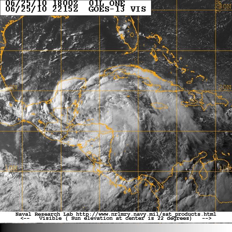
The water vapor image above shows a large area of very dry air over Texas and northern Mexico. There is no intrusion into Invest 95L yet, but if that air doesn't get removed from the area, that could also have an effect on it. With no surface circulation visible yet, this storm is far from becoming a depression. But with the warm ocean water below, the diurnal max overnight, and the topography of the Bay of Campeche area know for inducing cyclonic circulation, this storm can advance markedly overnight.


The image above is the mean wind steering map for the atmosphere top to bottom. This is one tool that helps us determine the track of tropical systems. The guidance is west towards Mexico. There is an alley of possible travel into the Gulf Coast, but the ridge over Florida is forecast to strengthen and move west to cover all of the Gulf states. The subtropical ridge over Texas is strong and expected to remain, that will throw the block on 95L to the north.

We will learn more tomorrow if the scheduled hurricane hunter mission is run. Then they will be able to determine where exactly the low level circulation is developing. Early indications was that there was a surface low developing in the southern bay, but now it appears that a more dominant low is forming further north near the top of the Yucatan. If that is the case, 95L will be able to make it a little further north before making landfall in Mexico. That should please the interests in southern Texas. That drought stricken area is begging for a mere drop of rain at this point.

DAY 26

The tropical disturbance in the western Caribbean is still just a broad area of thunderstorms. It has moved all the way up to the Yucatan Peninsula from the Nicaragua/Honduras boarder where it was at this time yesterday. The Hurricane Center is giving it a 20% chance of becoming a tropical cyclone over the next 48 hours.


A look at the visible satellite just before sunset reveals a very unorganized system. It does have a cyclonic or circular shape but there is no circulation visible on the loop. That might just be evidence of a mid level circulation that is trying to work it's way down to the surface. 


It does look now like it will get some time over open water in the Bay of Campeche. Judging by it's forward motion west/northwest so far, and by it's current orientation with the Yucatan. That can not be said for certain yet however because we don't know where exactly a surface circulation might be developing. If it is developing over the landmass, or wind shear is pushing on the upper part of the system, the convection may be well displaced from the center of circulation. But at this point it looks like this disturbance will get at least 1 full day over open water in the Bay of Campeche. It is there that it will find an environment very favorable for development. 


Jun 25, 2011

DAY 25

The pocket of convection off the coast of Nicaragua/Honduras has now prompted the Hurricane Center to include it in their Tropical Weather Outlook. The convection is being caused by a tropical wave that is interacting with an upper level trough. The winds from that trough are actually what's hindering this wave from developing at this point. Wind shear is forecast to become more favorable over the next couple of days. Another factor for the future of this system is it's proximity to land. If it does develop a surface circulation, it will have to be out over the open water to survive at such a young stage. The Hurricane Center is giving this system a 10% chance of developing into a tropical cyclone over the next 48 hours.

Click to unzoom

There is a strange bit of coincidence with this system and the first storm of last year. On this very same day last year, a storm system at that same location received the designation of Tropical Depression #1. You can see from the satellite photo below how well developed this system was at this point. It was drawing energy from the Caribbean and from the Pacific side of Central America as well. Once it moved into the Bay of Campeche it become the first Hurricane of the season, Alex.

DAY 24

There is an area of convection in the gulf of Mexico at the tail end of a cold front. Although areas like this are to be watched closely this disturbance is not expected to develop.


Once wind shear dies down, we will be watching a tropical wave in the southwest carribean. This will likely become the next invest area. It has not been listed on NHC's TWO day discussion yet but the ingredients are starting to come together in that area. It is competing for energy with a disturbance on the pacific side of central America and may develop it's center of cirrculation to close to the landmass but regardless this is something to keep an eye on.

Jun 23, 2011

DAY 23

Still Waiting for something significant.

DAY 22

Strong vertical wind shear is still preventing development. An area of 50 knot shear is pestering a tropical wave in the Central Caribbean. And an area of 30 knot shear is over the Bay of Campeche. However all the computer forecast models are consistent with reducing shear in that area by the weekend allowing a surface low to develop in the Bay of Campeche by Monday.

Jun 22, 2011

DAY 21

The African Monsoon Trof is all the way up to 20N Latitude on the African Continent. That will likely mean that tropical waves spawned off of west Africa will be strong and will be lobed directly into the Caribbean.
Many of the waves so far this season have been quite impressive looking for this time of year, but the environment in the Atlantic just hasn't allowed them to develop. If those waves are still that strong when we get favorable cyclone conditions, we might get a few monstrous Cape Verde type hurricanes this year.

Jun 21, 2011

DAY 20

A few waves in the Atlantic are not expected to develop, at least not anytime soon. Still waiting for the environment to support upward motion with low vertical shear. That is still forecast to occur this coming weekend.

Jun 20, 2011

DAY 19

A tropical wave over the Yucatan will enter the Bay of Campeche in the next couple of days. If anything, it will at least lower surface pressure there and bring some convection to the area. The upper level environment is still not favorable for development however.


Another wave just entering the Caribbean is quite battered at the time, but could show some more organization later on this week.


BTW, Tropical Storm Beatriz is born in the Pacific.

Jun 19, 2011

Jun 18, 2011

DAY 17

Storm activity in the southwest Caribbean still not expected to develop. Wind shear still very high. Some of the Global Forecast models still indicating there might be development in this area next weekend, by about the time the next wave arrives to this area.

Jun 17, 2011

DAY 16

One wave moving into the Gulf and one wave moving into the Caribbean. No development is expected in the next 48 hours, except in the Pacific were they have a surface low developing into a tropical cyclone.

Jun 16, 2011

DAY 15

The only action in the Atlantic is occurring in Central America. This stuff is moving westward into the Pacific however, and will likely become their second storm of the season out there.

Jun 15, 2011

DAY 14

Couple of waves entering the Caribbean are not expected to develop. The Caribbean is an unfriendly place for tropical features at the moment. The lows along the trough axis in Central America are seasonal features along a convergence zone and are not expected to produce anything soon either.

Jun 14, 2011

DAY 13

As of 11pm EDT June 13th, it has been 1003 days, 19 hours, and 50 minutes since the last landfalling hurricane in the United States. That was Hurricane Ike that hit Galveston, Texas on September 13th 2008 at 3:10am EDT.
That's the longest stretch of time without a landfalling hurricane in the U.S. since 2002 when hurricane Lili made landfall in Louisiana on October 2nd, which was 1083 days after hurricane Irene made landfall in Florida in October of 1999.

File:HGX N0R Legend 0.png
(Hurricane Ike making landfall in Galveston on Sept. 13th, 2008)

The Tropical Atlantic is quite right now and is expected to remain so for the next 5-7 days. One of the reasons is a Climate Phase called the Madden Julian Oscillation, named after the scientists that discovered it. When it is in a positive phase like it is now, it favors sinking air and higher surface pressures in the Atlantic. It is forecast to switch to a negative phase in about 7-10 days from now. Then rising air and lower surface pressures will exist, which is a more favorable environment for tropical cyclone development.

At the end of June last year there was favorable conditions in the Atlantic and an African Easterly Wave wondered into that environment and we got Hurricane Alex, a rare June hurricane. There is strong wave coming off of Africa right now that will be entering the Caribbean at about just the right time. Some of the long range forecast models are already picking up on this as a possible tropical storm in about 10 to 14 days.

Jun 13, 2011

DAY 12

Nothin Brewin right now. The remnants of 94L is a couple hundred miles off the coast of the Carolinas, and there are a few tropical waves making their way across the Atlantic. No tropical cyclone development is expected  over the next two days.


One of those waves approaching the leeward Islands was easily picked out on this satellite image. The 'Inverted V' cloud formation occurs along the bend in the isobars. The trough axis is right down the middle staring at the top of the bend.


Jun 11, 2011

DAY 10

Very little rain in Florida today, and we got no help from 94L as it slipped through the Florida Straight keeping all of it's rain in the Bahamas. The low actually became visible in the clouds tonight just to the north of Grand Bahama.


The Hurricane Center is giving it a near 0% chance of developing in the next 48 hours. However it does look better than it has in 3 or 4 days. It is located in an area of low shear and relatively warm water but it is just about the end of time for 94L. The upper level low in the Gulf is delivering some shear to the system along with a stream of dry air. It will take a little ride on the Gulf Stream before accelerating up the east coast  were it looks like it will meet up with a low pressure system coming off out of the north east US.

Jun 10, 2011

DAY 9

IT'S BACK.. 94L is back, sort of. It's back to being 94L. We've come to know this invest over the past several days as a tropical low that just can't pull it's act together. Satellite images show thunderstorm activity very far removed from the surface low. This is a result of 30 to 50 mph vertical shear.


The reason 94L has been placed back on the watch list is likely that wind shear is forecast to weaken in the next few days. This 72 hour upper wind profile shows the shear decreasing to a max of 30 mph in the region. This is still not favorable for tropical cyclone development, but it is less prohibitive than it has been. The width of that field is also much more narrow.


Whether or not 94L will be able to capitalize on this environment is yet to be seen. It may be able to deliver some much needed rain to Florida however. In order for this to happen, the low will have to move up into the Gulf of Mexico. The continued shear will keep the thunderstorm activity to the east as the low moves northward. The closer the low tracks to Florida, the less likely that Florida will receive any of it's rain. None of the model runs develop this feature and have this weak low track across the southern tip of Florida.

Jun 9, 2011

DAY 8

Invest 94L has been stripped of it's designation and now has no chance to develop over the next 48 hours. The surface low does still remain in the northwest Caribbean near the Cayman Islands but wind shear is expected to strengthen in that area over the next several days. Meaning tropical development in the coming week is very unlikely.

The moisture however is still in place and is still pestering Cuba, Jamaica and Hispaniola. That tropical moisture will gradually work it's way northward, bringing rain to the Bahamas and hopeful Florida.as well.


The only other features noticeable in the Atlantic pose no real treat at this time. There is a large bow shaped cloud formation in the middle of the ocean from the Leeward Islands all the way to Canada. Those are being forced by a massive cold front. There is a tropical wave approaching the Windward Islands but there is no thunderstorm activity associated with that at this time. And there is a group of thunderstorms filtering off of the African coast. None of the forecast models are developing any features in the Tropical Atlantic for the next few days.

Jun 8, 2011

DAY 7

The return of upper level shear is what marked the progress of 94L today. In the satellite loop below,  you can see the upswing of a trough coming off of the Yucatan scraping  the northwest side of the tropical disturbance. Towards the end of the loop there are some thunderstorms firing on the western end of Cuba that are getting their tops wiped out.


Things are only going to get worse for 94L as it ventures further into that shear to the north. The Hurricane Center is now only giving it a 10% chance to become a tropical cyclone in the next 48 hours.

It doesn't have to be a cyclone to be dangerous though. 94L has brought heavy rain to Jamaica, Cuba, and Hispaniola. In Haiti, 23 people are dead and many more are missing after almost a week of rain caused mudslides and widespread flooding.


BTW Tropical Storm Adrian has formed 355 miles south of Acapulco in the Pacific.

Jun 7, 2011

DAY 6

The system 94L remains very broad and unorganized today despite ample moisture now existing in that part of the Caribbean. Thunderstorm activity remains to the northwest of the the low again today, except of that flareup over the Nicaragua/Honduras border.


It is expected to begin a slow north or even northwestern movement in the next day or so. That is where it may encounter it's demise. The Sup-tropical Jet is still located across the Gulf of Mexico bringing about 50knots of sheer to the region and that sheer is expected to increase as the week goes on.


The National Hurricane Center is sticking with a 40% chance of development as of it's 8PM outlook. The Hurricane Hunter Mission was cancelled today due to the lack of organization to the system. Another flight is tentatively scheduled for tomorrow afternoon.

Jun 6, 2011

DAY 5

94L is still roughly located in the same position it has been for 3 days. It has gone through several thunderstorm cycles throughout the day, and the rotation around the low pressure center is very broad and very noticeable on satellite loops.


Water Vapor images show that the mid level is not as dry its been. This morning however, there was still a lot of dry air. In the satellite image below, you can see a massive outflow boundary as 94L spit out some cold dense air. I've pointed out where this air hit the ocean surface and formed Arc Clouds which rapidly spread out from the main convection after impacting the surface.


Persistent rain from 94L has taken it's toll on Jamaica. Emergency Management in Jamaica is reporting that the river Yallahs is flooding, several communities are flooded and several roadways are impassable. Also a local fisherman is lost at sea and presumed drowned after his boat overturned at Bob Marley Beach in Saint Andrew Parish. Another 
man was rescued from that boat. A flash flood warning is in effect until 5am.


The Hurricane Center is giving 94L a 40% chance of becoming a tropical cyclone by Tuesday night. I won't be listing any model tracks or talking about steering in this blog until there is a tropical cyclone. There is a Hurricane Hunter Aircraft Mission scheduled for Monday afternoon.

Jun 5, 2011

DAY 4

93L dissipated shortly after making landfall in the Mexican State of Tamaulipas about 110 miles south of Brownsville, Texas this morning. The Rio Grande Valley, which was praying for any drop of rain from 93L, received not one drop. It remains along with most of Texas in a Severe Drought situation. 

Different story in Jamaica where all Parishes are under a Flash Flood Watch until 5am local time. 94L battled dry air entrainment all day long. It doesn't look any better today in fact it looks a little less organized. The National Hurricane Center has downgraded its chances of becoming a tropical cyclone in the next 48 hours to 20%. It is currently showing a large flare up of storms over the eastern part of Jamaica.


It has remained fairly stationary and is forecast to remain so for another 24 hours. Dry air to its northwest continues to hamper development. And sometimes stationary storms tend to cause upwelling of cooler ocean water although I don't think that is as much an issue without low surface pressure and a tight center of circulation. 

There is also a tropical wave entering the Caribbean through the Lesser Antilles. We'll have to see how 94L reacts to this. Forecast models are showing 2 lows splitting away from the Windward Passage, this wave might have something to do with that.

Jun 3, 2011

DAY 3

93L has been nothing more than an empty spin for much of the day but it is still holding together. It will run aground in Northern Mexico sometime late tonight or early Saturday morning. It will likely bring breezy conditions and light rain to the areas just south of the Rio Grande.

The massive blob in the west-central Caribbean has now received the designation 94L and has grown a bit more organized today. It is showing convection close to the center of circulation which is just south of Jamaica.


Upper level westerly wind flow has let up a bit making the environment for development much more favorable. The Hurricane Center is currently giving it a 30% chance of becoming a Tropical Cyclone over the next 48 hours. We'll have plenty of time to keep an eye on this thing because it is forecast to remain stationary for a couple of days. Thats bad news for Jamaica, Haiti, Cuba and the Caymans as they will likely receive heavy amounts of rain over the next 48 hours.


The dry patch seen in this water vapor image is the only thing really hindering it at the moment, besides the moderate level of sheer. The low is located in an area of the Caribbean know for rapid development. Just because it is early in the season, there is now reason to doubt that that could happen.

DAY 2

93L is now located North of the Yucatan and still looks to be a battered disturbance. Satellite loops show that it does still have a fairly tight surface circulation and its forward progress seems to have slowed quite a bit. However it is still battling the dry air that is currently situated in the Gulf which you can see in this water vapor image.  It also shows that it is being sheered on its southern section by a strong westerly current.


It looks like it will just barely survive long enough to make it to Mexico. The Hurricane Center is giving it a 10% chance of developing into a Tropical Cyclone.

Meanwhile there is still a surface low spinning off the coast of Nicaragua. There is obvious sheering going on here as well as you can see the main thunderstorm activity is well removed to the east of the low. The models have changed their tune and now longer favor development of this system.


One other thing to mention tonight is another cluster of thunderstorms possibly moving into the Gulf stream. That is how 93L got its start. It came from much farther north though across New England.